Florida Trail - Segment 2
We're used to the instant gratification of digital photography! But the hikers didn't want to take a digital camera on their trek, so we had to wait for the disposable camera's film to get developed and uploaded. Finally, we're ready to "finish" the adventure. Since it's been a while, you can check out previous posts here and here.
Finally, time for a few details! Here's a map of the Florida Trail (marked in red).
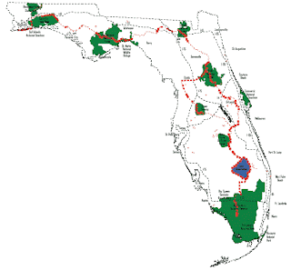 Segment one is about 8 miles long and starts at the southern end, in Big Cypress National Preserve. Segment two comes next and is about 30 miles long.
  It was a beautiful day to begin hiking!
Typically segment two is under water, and so the plan was to go at the end of the dry season (i.e., Spring Break) to minimize the trudging through the wet everglades. However, Florida is having a drought. It turned out the problem was not enough water. That made the backpacks VERY heavy, because they couldn't count on finding drinking water and had to carry it all with them.
 Here are some pictures of the world's driest swamp. There are wispy pine trees and palmettos and cypress trees, none of which provide a lot of shade. The first two days weren't too bad, but the last day was long and sunny and hot! However, they made it, and that's what counts.
 The end of the trail - at least for now - the I-75 rest area on Alligator Alley.
Finally, time for a few details! Here's a map of the Florida Trail (marked in red).
 Segment one is about 8 miles long and starts at the southern end, in Big Cypress National Preserve. Segment two comes next and is about 30 miles long.It was a beautiful day to begin hiking!
 Typically segment two is under water, and so the plan was to go at the end of the dry season (i.e., Spring Break) to minimize the trudging through the wet everglades. However, Florida is having a drought. It turned out the problem was not enough water. That made the backpacks VERY heavy, because they couldn't count on finding drinking water and had to carry it all with them.
 Here are some pictures of the world's driest swamp. There are wispy pine trees and palmettos and cypress trees, none of which provide a lot of shade. The first two days weren't too bad, but the last day was long and sunny and hot! However, they made it, and that's what counts.
 The end of the trail - at least for now - the I-75 rest area on Alligator Alley.
Comments